
Miss Patricia Davies, the first Headmistress I worked under at Church High, is undoubtedly the person who moulded me most as a young teacher. So much so that we are still in touch to this very day. From our Archive, it seems some of the first correspondence Tricia had to deal with on taking up her new role was to reply to a letter sent to her predecessor, Miss Lewis, in September 1974 from Tom Lind, Consultant Obstetrician, at the Princess Maternity Hospital. The query? Welcome to the thorny issue of the ‘wayleave’. Tricia’s reply ends: ‘If you have any further questions about the footpath, please do not hesitate to get in touch with me.’ That was then, but this is now.

As early as 2015, I was asked about the footpath in question. While we worked on the Tankerville site at Church High, it wouldn’t have crossed anyone’s mind to question our right of access via the side footpath to the playing field beyond. True, there was a gate to pass through when you left the School grounds to walk past the Princess Mary Hospital, which became a private housing complex in 1993.


However, the fact the gate was always open may mean some people won’t remember it at all. But it was there. Now it is firmly closed.

Which is how I ended up requesting item E.NC17/1/12/10 from the Church High Archives at The Discovery Museum in August 2016: ‘Documents relating to the acquisition of land in Tankerville Gardens for the use of the school, the leasing of land for the erection of a new junior school and the sale of the school playing fields in Reid Park Road’. A hefty file covering a period from 30 October 1958 – 5 October 1974. And very interesting it all was too. The paperwork makes clear that an agreement between Church High and the University, who formerly owned the Princess Mary land, was in existence prior to 1958 when King’s College were planning to build a Moor Edge Hostel (along with a path running north of Church High’s boundary wall) and continued until we left the site in July 2014. The hostel was never built, but the right of way agreement remained. Such a useful short-cut. The Princess Mary building began its life, you may recall, as The Northern Counties Orphanage, made up of two separate institutions on the Moor Edge site: the Abbot Memorial Building, constructed in 1867 to accommodate 60 girls, followed by the Jane Philipson Memorial Building in 1878 to allow boys to be housed on the site. In the same year as Newcastle High School was founded in Jesmond Road, 1885, the Adamson Memorial Chapel was built to link the two orphanages. Do look at the weblinks, if you can find the time; the social history of Moor Edge is fascinating.


For over 20 years after the end of World War II, Church High had ‘a longstanding and friendly but unofficial arrangement’ with King’s College, University of Durham, allowing use of part of the land which once served as the Orphanage Garden as a ‘playing area for children.’ The University themselves leased the entire Orphanage plot from the St Mary Magdalene and Holy Jesus Charity. Thanks to P.C.’s memoir, ‘The Glory and Freshness of a Dream’ in the Jubilee history, we know that Hockey was played there before the playing fields on Reid Park Road were acquired. Again in a 1961 letter, the Bursar of King’s College, refers to the land as their ‘building site’ which Church High is ‘temporarily using as a playing field’ when the issues of litter and people exercising their dogs on the land were raised. The compromise reached was to fence off the eastern edge along Tankerville Terrace including a gate to the side of the School, with keys provided for both Church High and the Princess Mary.


Our attention then turned to discussing the brand-new, electronic pedestrian gate, as yet to be unloaded from the lorry, you may recall.

The smaller gate’s appearance was no surprise at all to me, as Giuseppe had already included various working sketches of it in his download feed. Both black powder-coated galvanised steel auto gates were constructed by GMC Fabrication Services and were being installed by Davison Fencing. Presumably the concrete foundations for the single-leaf auto gate were also already in place.


As you already know, I wasn’t able to stay to see the new pedestrian gate being installed, but I located its proposed position before I left.

An earlier photograph of Giuseppe’s shows the ground being cleared for the new pedestrian gateway. This used to be a slightly raised bedding area containing shrubs and greenery, you may recall.

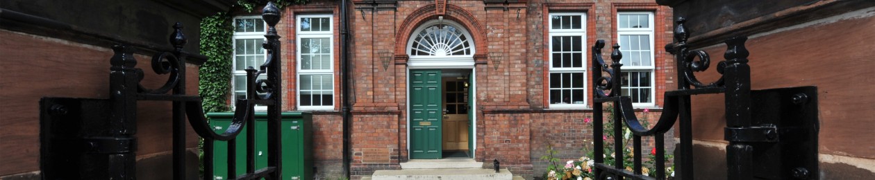
 As this will be the last post I shall write in 2017, it seems fitting to end with pictures of the newest pathway on the Tankerville site. It’s a more circuitous pathway than the old one, true, but then life is all about the journey and not the destination, I am sure you will agree.


 As I wish you all a Happy New Year, I will finish off 2017, a year that hasn’t been the easiest for me personally, with one of my favourite Bible quotations. It is from Isaiah 43: 19 and offers us all a promise: ‘Behold, I will do a new thing; now shall it spring forth; shall ye not know it? I will even make a way in the wilderness, and rivers in the desert.’ Newcastle High School girls may now have to go the long way round to the Moor Edge Intake field, but I hope 2018 is a good one for all.
I would like to say thank you so much for sharing your blog. I was enjoying reading your article and I will be back soon for more update.
Thank you for the kind words of support, David. The blog has been a little ‘labour of love’ for me. Were you by any chance one of the guys who worked on installing the gates?